Places
Rahim Yar Khan
About this place
Rahim Yar Khan is one of the major districts of southern Punjab and an important part of the wider Saraiki cultural region. Located between the Indus River and the Cholistan Desert, the district contains a remarkable combination of riverine landscapes, irrigated agricultural plains and vast desert territory.
The district is known for its agricultural economy, Saraiki culture, historic settlements, desert traditions, livestock, traditional crafts and important towns including Rahim Yar Khan, Khanpur, Sadiqabad and Liaquatpur.
Its location at the southern edge of Punjab also gives Rahim Yar Khan a distinctive geographical position. The district connects southern Punjab with Sindh to the southwest, Bahawalpur to the northeast, Rajanpur to the west and the international border with India to the southeast.
Rahim Yar Khan's story is therefore a story of rivers and deserts, agriculture and pastoral life, historic settlements and modern industry.
GEOGRAPHY & LOCATION
Rahim Yar Khan District is located in the southern part of Punjab.
It is bounded by Muzaffargarh District to the north, Bahawalpur District to the east, Rajanpur District to the west, Sindh's Ghotki District toward the southwest and the Indian state of Rajasthan to the southeast.
The district covers approximately 11,880 square kilometres.
According to the 2023 Census, Rahim Yar Khan District had a population of 5,564,703 people.
The district is divided into four tehsils:
• Rahim Yar Khan
• Khanpur
• Sadiqabad
• Liaquatpur
Its geography can broadly be understood through three major environments: the riverside zone, the irrigated agricultural tract and the Cholistan Desert.
RIVER, PLAIN & DESERT
One of Rahim Yar Khan's most distinctive characteristics is the transition between three different landscapes.
The western and southwestern areas are influenced by the Indus River and its riverine environment.
The central agricultural belt is supported by irrigation and contains extensive cultivated land.
Farther south and southeast, the landscape gradually changes into the sandy environment of Cholistan.
This combination gives Rahim Yar Khan a geographical diversity that is unusual within a single district.
THE INDUS RIVER
The Indus River is one of the most important geographical features of Rahim Yar Khan.
The river has influenced settlement, agriculture, transportation and the natural environment of the district for centuries.
Riverine areas contain fertile soils and support agriculture, vegetation and wildlife.
The relationship between the Indus and the surrounding settlements has also shaped the economic history of southern Punjab.
THE CHOLISTAN DESERT
The southern part of Rahim Yar Khan extends into the Cholistan Desert, traditionally known as Rohi.
Cholistan is characterized by sand dunes, dry plains, sparse vegetation and scattered settlements.
The desert continues toward the international border with India.
Despite its harsh climate, Cholistan has supported human communities for centuries.
Pastoralism, livestock, camel keeping, handicrafts and seasonal agriculture have traditionally been important to desert communities.
ROHI & SARAiki CULTURE
Rohi is not simply a geographical name.
Within Saraiki cultural expression, Rohi represents a landscape of poetry, folk traditions, migration, pastoral life and spiritual symbolism.
The desert has inspired generations of Saraiki poets and storytellers.
Themes of separation, love, longing, nature, spirituality and desert life appear throughout the wider literary tradition of southern Punjab.
Rahim Yar Khan's connection with Rohi therefore forms an important part of its cultural identity.
HISTORY OF RAHIM YAR KHAN
The history of the area extends far beyond the modern name of Rahim Yar Khan.
The official district history records several historical names associated with the settlement and surrounding area, including Pattan and Naushera.
The modern town of Naushera was established in the nineteenth century and later became known as Rahim Yar Khan.
The district was established as a separate administrative district in 1943.
The present name is connected with Rahim Yar Khan, the son of Nawab Sadiq Khan IV of Bahawalpur.
NAUSHERA
Before becoming Rahim Yar Khan, the settlement was known as Naushera.
According to the official district history, Naushera was developed in 1875 on the site of an older settlement.
When railway authorities encountered another town with the same name, the name of the settlement in Bahawalpur State was changed in 1881.
It was renamed Rahim Yar Khan in honour of the son of Nawab Sadiq Khan IV.
The new name eventually became associated with the town and later the district.
BAHAWALPUR STATE
Rahim Yar Khan formed part of the former Bahawalpur State.
The Abbasi rulers of Bahawalpur exercised authority over the region for generations.
The area's location was strategically important because it connected the agricultural plains of Bahawalpur with the desert and the routes leading toward Sindh.
The legacy of Bahawalpur State can still be seen in the architecture, historical settlements and cultural traditions of southern Rahim Yar Khan.
BRITISH PERIOD
During the British period, the area remained connected with the princely State of Bahawalpur while British influence expanded across neighbouring Punjab.
Railway development played an important role in the growth of Rahim Yar Khan.
The railway connected the area with Bahawalpur, Sindh and other major centres.
Improved transportation encouraged trade and agricultural development.
RAILWAY HERITAGE
Railways became an important part of Rahim Yar Khan's modern history.
The district lies along an important north-south railway corridor connecting southern Punjab with Sindh and other parts of Pakistan.
The railway helped transform local settlements into commercial centres by improving the movement of agricultural products, people and goods.
Today, rail connectivity remains an important part of the district's transportation network.
RAHIM YAR KHAN CITY
Rahim Yar Khan is the administrative headquarters of the district and one of its principal urban centres.
The city has expanded significantly over the decades.
Modern Rahim Yar Khan contains residential areas, markets, educational institutions, hospitals, government offices, industries and transport facilities.
At the same time, its surrounding agricultural landscape continues to influence the city's economy and daily life.
KHANPUR
Khanpur is one of the major towns of Rahim Yar Khan District.
The town is surrounded by an important agricultural region and has developed as a commercial centre serving nearby rural communities.
Khanpur is also associated with the wider cultural traditions of southern Punjab.
Its markets and surrounding villages contribute to the region's agricultural and commercial economy.
SADIQABAD
Sadiqabad is another major urban centre of the district.
The city is named after the Bahawalpur ruler Nawab Sadiq Muhammad Khan.
Sadiqabad developed into an important commercial and industrial centre because of its location near the southern edge of Punjab and its connections with Sindh.
The city also serves as an important gateway between Punjab and Sindh.
LIAQUATPUR
Liaquatpur is located in the northern part of Rahim Yar Khan District.
The town and surrounding tehsil contain extensive agricultural areas.
Liaquatpur forms part of the district's network of markets, villages and transport routes connecting northern Rahim Yar Khan with Bahawalpur and other parts of southern Punjab.
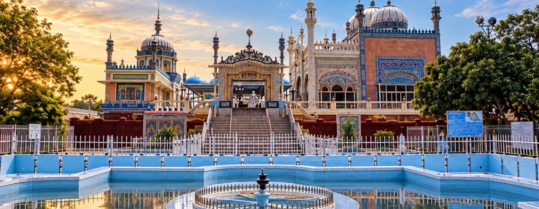
BHONG MOSQUE
The Bhong Mosque is one of the most distinctive architectural landmarks associated with Rahim Yar Khan District.
Located near Bhong in Sadiqabad Tehsil, the mosque is famous for its elaborate decoration and intricate craftsmanship.
Its architecture combines Islamic, South Asian and regional artistic traditions.
The building is particularly known for its detailed tilework, calligraphy, mosaics, carved elements and decorative interiors.
The Bhong Mosque received international recognition when it was awarded the Aga Khan Award for Architecture in 1986.
Today it represents an important example of modern Pakistani Islamic architecture and traditional craftsmanship.
PATTAN MINARA
Pattan Minara is an important archaeological and historical site in the Rahim Yar Khan region.
The brick tower stands near the city and is associated with the ancient settlement history of the area.
Its exact origins and historical interpretation have been discussed by different historians, but the monument is widely recognized as an important part of the region's archaeological heritage.
The structure provides a visible link between modern Rahim Yar Khan and the much older settlement history of the surrounding region.
ANCIENT SETTLEMENTS
The area around Rahim Yar Khan has experienced settlement for many centuries.
Its location between the Indus basin, Cholistan and routes toward Sindh made it an important geographical corridor.
Archaeological remains and historical monuments indicate that communities have occupied different parts of the region over long periods.
The transition between riverine settlements and desert settlements also created different patterns of life across the district.
DESERT FORTS & SETTLEMENTS
The Cholistan portion of Rahim Yar Khan contains remains of historic forts, wells and settlements.
These structures were connected with older routes across the desert.
Water was the most important resource for travellers, livestock and settlements, making wells and water reservoirs essential.
Historic forts helped protect routes and provided strategic positions across the desert.
Many of these structures are now archaeological and cultural heritage sites.
CHOLISTAN'S WATER TRADITION
Life in Cholistan has always depended on water.
Traditional communities relied on wells, ponds and other sources to support people and livestock.
Settlements often developed around available water resources.
This relationship between water and desert life shaped local architecture, migration patterns, livestock practices and settlement geography.
AGRICULTURE
Agriculture is one of the foundations of Rahim Yar Khan's economy.
Large areas of the district are cultivated through irrigation.
Major crops include cotton, wheat, sugarcane and other agricultural products.
The district also contains extensive orchards and areas dedicated to fruit cultivation.
Agriculture provides employment and income for a large rural population and supports the district's food-processing and industrial sectors.
COTTON
Cotton is an important crop in the agricultural economy of Rahim Yar Khan.
The crop supports local ginning and textile-related activities.
The hot climate and irrigated agricultural land provide suitable conditions for cotton cultivation.
Cotton production connects the district with the wider textile economy of Punjab.
SUGARCANE
Sugarcane is another important agricultural crop.
The district has several sugar mills that process locally produced sugarcane.
The sugar industry connects farmers with processing facilities and contributes to the industrial economy of the region.
MANGOES & FRUIT
Rahim Yar Khan is also known for fruit production.
The irrigated agricultural environment supports mangoes and other fruit crops.
Orchards contribute to the rural economy and form an important part of the agricultural landscape.
The combination of crops, orchards and livestock makes agriculture a diverse sector within the district.
LIVESTOCK
Livestock is particularly important in the desert and rural areas.
Cattle, buffaloes, goats, sheep and camels are raised throughout the district.
For Cholistan communities, livestock has traditionally been central to household livelihoods.
Camels are especially well adapted to the desert environment and have historically provided transportation as well as economic value.
CAMEL CULTURE
The camel is one of the most recognizable animals associated with Cholistan.
Before modern transportation became widespread, camels were essential for travelling between desert settlements.
Camel caravans carried people, water and goods across long distances.
Although their practical role has declined, camels remain an important cultural symbol of Rohi and Cholistan.
DESERT CRAFTS
Traditional crafts form an important part of Cholistan's cultural heritage.
Embroidery, weaving, pottery, leatherwork and decorative textiles are produced by local communities.
Women artisans in particular have preserved detailed embroidery traditions.
Bright colours, geometric patterns and traditional motifs are common features of Cholistani textiles.
These crafts provide both cultural continuity and economic opportunities.
CHOLISTANI DRESS
Traditional clothing in Cholistan is known for its vibrant colours and decorative embroidery.
Women's garments often feature elaborate stitching, colourful threads and ornamental details.
Men commonly wear traditional loose garments suited to the hot desert climate.
Clothing traditions vary between communities but remain an important expression of local identity.
SARAiki LANGUAGE
Saraiki is widely spoken across Rahim Yar Khan and forms an important part of everyday cultural life.
The language is used in homes, markets, villages, poetry, music and traditional storytelling.
The district's position within the Saraiki cultural region has helped preserve a strong connection between language and local traditions.
SARAiki LITERATURE
Rahim Yar Khan and the surrounding Rohi region are connected with the wider literary traditions of southern Punjab.
Saraiki poetry frequently draws on the landscapes and experiences of the region.
The desert, river, agricultural fields, seasons, relationships and spiritual traditions provide recurring themes.
The poetry of Khwaja Ghulam Farid has particular cultural significance for the wider Rohi region.
KHWAJA GHULAM FARID & ROHI
Khwaja Ghulam Farid is one of the most important Sufi poets associated with the Saraiki language.
His poetry is strongly connected with the landscape of Rohi.
He described the desert's dunes, plants, animals, seasons and settlements while using the landscape as a setting for spiritual and emotional expression.
His literary legacy has contributed greatly to the cultural identity of the wider Cholistan region.
FOLK MUSIC
Rahim Yar Khan's rural and desert communities have preserved a variety of folk music traditions.
Songs are associated with weddings, seasonal events, love, separation, work and spiritual gatherings.
Traditional instruments and oral performance have helped transmit songs and stories between generations.
Sufi poetry is also performed through devotional music.
FOLK STORIES
Oral storytelling has historically been important among desert communities.
Stories of travelling heroes, lovers, saints, rulers and desert journeys have been passed between generations.
These stories provide insight into the values, experiences and imagination of communities living across Rohi.
FOOD CULTURE
Rahim Yar Khan's cuisine reflects the wider food traditions of southern Punjab.
Wheat, rice, lentils, vegetables, dairy products and meat form important parts of everyday meals.
Traditional breads, rice dishes, meat preparations, sweets and seasonal foods are common throughout the district.
Rural and desert communities also have food traditions influenced by livestock and pastoral life.
SWEETS & LOCAL MARKETS
Traditional sweets and snacks are widely available in the district's urban markets.
Local markets serve both urban residents and agricultural communities from surrounding villages.
The movement of agricultural products into these markets and manufactured goods back into rural areas forms an important part of the district's commercial life.
INDUSTRY
Rahim Yar Khan has one of the more diverse industrial economies in southern Punjab.
The district government lists industries including sugar mills, fertilizer production, food processing, flour mills, textiles and other manufacturing activities.
The district's agricultural output provides raw materials for many of these industries.
Industry therefore remains closely connected with agriculture.
FOOD PROCESSING
Agricultural processing is an important component of the local economy.
Sugar mills, flour mills, textile operations and other facilities process products originating from surrounding farms.
These industries provide employment and create connections between agricultural production and urban markets.
COMMERCIAL CENTRES
Rahim Yar Khan, Sadiqabad, Khanpur and Liaquatpur serve as important commercial centres.
Their markets connect farmers and rural communities with wholesalers, retailers and consumers.
The district's location between Punjab and Sindh also contributes to its role in regional trade.
TRANSPORT & CONNECTIVITY
Rahim Yar Khan is connected to the rest of Pakistan through highways, railways and air transport.
The district has an extensive road network linking its major towns and rural communities.
The railway provides an important north-south connection between Punjab and Sindh.
The district's location makes it an important transportation corridor between southern Punjab and upper Sindh.
SHEIKH ZAYED INTERNATIONAL AIRPORT
Rahim Yar Khan is served by Sheikh Zayed International Airport.
The airport provides an important air connection for the district and surrounding communities.
Its presence supports business, travel and access to the wider region.
EDUCATION
Education has expanded significantly across Rahim Yar Khan.
The district contains schools, colleges and higher-education institutions serving both urban and rural communities.
Educational institutions provide opportunities for students from the district and surrounding areas.
Higher education has also contributed to the growth of professional and technical skills in the region.
HEALTHCARE
Rahim Yar Khan is an important healthcare centre for southern Punjab.
Sheikh Zayed Hospital and Medical College is one of the major medical institutions serving the district.
Hospitals, rural health centres, basic health units and other facilities provide healthcare services across the district.
The healthcare sector also attracts patients from surrounding rural areas.
WILDLIFE
Rahim Yar Khan contains several different ecological environments.
The Indus riverine zone supports aquatic life and riverine vegetation.
The agricultural belt contains cultivated landscapes and orchards.
The Cholistan Desert supports species adapted to dry and sandy environments.
Birds, reptiles and desert mammals form part of the region's wildlife.
Conservation of these different habitats is important for preserving the district's natural heritage.
DESERT ECOLOGY
Cholistan's environment is shaped by limited rainfall, high temperatures and shifting sand.
Plants found in the desert are adapted to conserve water and survive dry conditions.
Seasonal rainfall can temporarily transform parts of the desert landscape.
The desert therefore has its own ecological cycles that are closely connected with traditional human settlement.
CLIMATE
Rahim Yar Khan has a hot and generally dry climate.
Summers are extremely hot, particularly in the desert areas.
Winters are comparatively mild.
The climate strongly influences agriculture, architecture, clothing and traditional ways of life.
The hot conditions also contribute to the suitability of the region for crops such as cotton and sugarcane when adequate irrigation is available.
RELIGIOUS HERITAGE
Religious traditions form an important part of Rahim Yar Khan's cultural landscape.
Mosques, shrines and historic religious sites can be found throughout the district.
The wider region has also been influenced by the Sufi traditions of southern Punjab.
Religious gatherings and shrine-related events continue to form part of community life.
UCH SHARIF & THE WIDER REGION
Although Uch Sharif lies in neighbouring Bahawalpur District, its Sufi heritage is closely connected with the wider cultural landscape of southern Punjab.
Communities throughout Rahim Yar Khan share many of the broader religious, linguistic and cultural traditions of the region.
The historical movement of scholars, traders and pilgrims across southern Punjab helped create these connections.
RAHIM YAR KHAN & CHOLISTAN
The relationship between Rahim Yar Khan and Cholistan is central to the district's identity.
The desert occupies a large part of the southern landscape.
Its communities, crafts, livestock, architecture and oral traditions contribute to the cultural character of the district.
The transition from irrigated farmland to desert creates one of the most distinctive landscapes in southern Punjab.
RAHIM YAR KHAN & SINDH
Rahim Yar Khan sits close to the Punjab-Sindh transition zone.
Its southern and western connections link the district with Sindh's Ghotki region and the wider Indus corridor.
Trade, transportation, migration and cultural exchange have historically crossed this regional boundary.
This has given Rahim Yar Khan a cultural character influenced by both southern Punjab and neighbouring Sindh.
RAHIM YAR KHAN & SARAIKISTAN
For Saraikistan, Rahim Yar Khan represents the southern edge of a vast Saraiki cultural landscape.
The district brings together Saraiki language, Rohi traditions, agricultural life, Indus river culture and desert heritage.
Its towns provide modern commercial and educational centres, while its villages and desert settlements preserve older cultural traditions.
The district demonstrates how diverse environments can exist within one connected cultural region.
LIVING HERITAGE
Rahim Yar Khan's heritage is not limited to monuments.
It lives in the Saraiki language spoken across the district.
It lives in the embroidery produced by Cholistani artisans.
It lives in the songs and stories of desert communities.
It lives in the agricultural fields along the irrigated plains.
It lives in the livestock traditions of Rohi.
It lives in the markets of Rahim Yar Khan, Khanpur, Sadiqabad and Liaquatpur.
It lives in the historic architecture of sites such as Bhong Mosque and Pattan Minara.
It lives in the relationship between the Indus River and the desert.
A LAND OF RIVER AND DESERT
Rahim Yar Khan is defined by contrast.
The Indus provides a riverine environment on one side of the district.
Irrigated agriculture transforms large areas into productive farmland.
Farther south, the landscape becomes the dry and expansive Cholistan Desert.
These environments have created different livelihoods, traditions and ways of life while remaining connected through language, trade and history.
MODERN RAHIM YAR KHAN
Modern Rahim Yar Khan is a growing urban and economic centre.
The district's cities contain schools, colleges, hospitals, markets, industries, government offices and transport infrastructure.
Agriculture remains fundamental to the economy, while manufacturing, services, trade and education continue to expand.
Despite this modernization, the district retains strong connections with its desert and rural heritage.
RAHIM YAR KHAN — WHERE ROHI MEETS THE INDUS
Rahim Yar Khan is a place where the landscapes of river and desert meet.
Its history connects the former Bahawalpur State with the modern Punjab province.
Its agriculture connects rural communities with major industries and markets.
Its desert communities preserve the traditions of Rohi.
Its Saraiki language connects it with the wider cultural world of southern Punjab.
Its historic monuments provide visible reminders of earlier civilizations and architectural traditions.
For Saraikistan, Rahim Yar Khan is more than an administrative district.
It is a cultural bridge between the Indus and Cholistan, between Punjab and Sindh, between agricultural plains and desert communities, and between historical traditions and modern life.
Its story is a story of movement, adaptation and continuity — a region shaped by rivers, roads, railways, agriculture, desert routes, trade, language and generations of people who continue to carry its heritage forward.